
Tsunami Landslide Storm

Friday, October 31, 2014
Wednesday, October 29, 2014
CDPH issues #Ebola quarantine order

News
Release
CALIFORNIA DEPARTMENT OF PUBLIC HEALTH

October 29, 2014
PH14-089
State Health Officer Issues Risk-Based Quarantine Order to
Provide Consistent Guidelines for Counties
Health
care providers and travelers returning from Ebola affected regions will be
individually assessed for exposure risk
SACRAMENTO
- While there continue to
be no reported or confirmed cases of Ebola in California, State Health Officer
and California Department of Public Health (CDPH) Director Dr. Ron Chapman
today took action to help prevent any potential spread of the disease in the
state by issuing a quarantine order and associated guidelines that require
counties to individually assess persons at risk for Ebola and tailor an
appropriate level of quarantine as needed. This flexible, case-by-case approach
will ensure that local health officers throughout the state prevent spread of
the disease, while ensuring that individuals at risk for Ebola are treated
fairly and consistently.
Quarantine Order
“Today we’re
establishing a statewide, standard protocol requiring some level of quarantine
for those at highest risk of contracting and spreading Ebola,” said Dr.
Chapman. “This order will protect the health and safety of Californians and
support the state’s local health officers’ existing authority to develop
protections against disease spread.”
The order,
which applies to anyone traveling to California who has 1) traveled to
California from an Ebola affected area; and 2) has had contact with someone who
has a confirmed case of Ebola, requires those travelers to be quarantined for
21 days. A person traveling to this region that has not come into contact with
a person with Ebola will not be subject to quarantine. An Ebola affected area
is one determined as an active area by the federal Centers for Disease Control
and Prevention (CDC), which currently includes Guinea, Liberia and Sierra Leone.
California Department of Public Health
and Local Health Officers Partner
Local County
health officers will issue quarantine orders for individuals and establish
limitations of quarantine on a case-by-case basis. These limitations will be based on new
guidance also released today by CDPH. This “Guidance
for the Evaluation and Management of Contacts to Ebola Virus Disease” outlines
quarantine limitations that local health officers should take based on the
level of Ebola risk to which individuals were exposed. Although quarantine can
involve isolation at home, it may be tailored to allow for greater movement of
individuals who are deemed to be at lower risk.
“Not everyone
who has been to an Ebola affected area should be considered high risk,” Dr.
Chapman said. “This order will allow local health officers to determine, for
those coming into California, who is most at risk for developing this disease,
and to contain any potential spread of infectious disease by responding to
those risks appropriately.”
In
California, local health officers currently have the authority to order
quarantine of people who may have an infectious disease that threatens public
health. This order will ensure consistent application across the state of
quarantine for high risk individuals in order to control risks from Ebola.
California is
home to many health care workers who have selflessly volunteered to help combat
the current Ebola epidemic in Guinea, Liberia and Sierra Leone. These individuals are engaged in stemming
this epidemic at its source through a range of activities, from direct care of
confirmed Ebola patients to health education of the general population. California
is also receiving residents returning from travel to these three countries as
well as visitors from this region.
“Health care
workers who go to Ebola affected countries to treat patients are great
humanitarians. They will be treated with respect and dignity when they come
home as these important public health actions are taken,” said Dr. Chapman. “We
value those who volunteer to help those in need, and appreciate their
willingness to serve.”
Today’s Order
is available on the CDPH website, cdph.ca.gov, as is the Guidance to local
health officers for implementing the order.
California Public Health Actions to
Date
Since the Ebola outbreak began in
Guinea, Liberia and Sierra Leone, CDPH has worked with state, federal and local
health officials to prepare for potential cases of Ebola in California. In
August, CDPH launched an informational website compiling
information about the outbreak and preparing California health care providers
with guidance and protocols from the CDC. CDPH has developed an interim case report form for reporting
suspected cases of Ebola to CDPH and has distributed CDC guidance on specimen collection, transport, testing and
submission for patients suspected of having
Ebola. Last week, CDPH posted interim guidelines for Ebola medical waste management and
recommended that all health care facility environmental services personnel and
infection control staff work together to develop facility-specific protocols
for safe handling of Ebola related medical waste. CDPH has provided these and
other documents to health care providers and partners via the California Health
Alert Network (CAHAN).
In September, CDPH convened more than 1,100 health care and public health workers to urge them to assess their Ebola readiness and conduct drills in their facilities. Last week, CDPH officials held a teleconference with health care providers to discuss the latest news and guidance about handling suspected Ebola cases. CDPH is providing weekly updates to local health officials, first responders and health care providers as the Ebola outbreak continues in West Africa. CDPH launched a telephone hotline call center to respond to public inquiries related to Ebola. In October, Governor Brown joined officials from the California Health and Human Services Agency (CHHS), CDPH, Department of Industrial Relations (DIR) and Cal/OSHA to meet with California hospital leaders, nurses, emergency responders, local health directors and medical providers. Last week the University of California Medical Centers were identified as priority hospitals for the treatment of confirmed Ebola cases.
CDPH is also available to provide consultation about suspect Ebola cases to local health departments and health care providers 24 hours a day, 7 days a week. CDPH joins with a team of state departments and agencies including CHHS, the Governor’s Office of Emergency Services (CalOES), Emergency Medical Services Authority (EMSA) and DIR, to address all aspects of preparedness for a potential Ebola case in California.
For more information about how the state is preparing for potential cases of Ebola, please read CDPH's Ebola Virus Disease FAQs and visit the CDPH Ebola Virus Information Page and the Cal/OSHA Ebola Virus Information site.
Tuesday, October 28, 2014
Hope that your costume has a raincoat - Central Coast rain!!

Overview
A strong Pacific storm system is on track to impact the San Francisco/Monterey Bay Region Thursday night through late Friday night. Rains along the cold front will develop across the North Bay Thursday night and spread southward through Friday morning. Thus, light to moderate rainfall will likely wreak havoc on the Friday morning commute across the San Francisco Bay Area. As the main upper level system moves across, rain showers and the possibility of embedded thunderstorms will continue through Friday afternoon and evening region-wide. In addition, these conditions will likely impact any Halloween activities planned for Friday evening. |
CONFIDENCE
· High: Timing
of frontal passage and likelihood of precipitation
· Low to
Moderate: Thunderstorm potential & exact rainfall amounts
TIMING
& LOCATIONS
· Rains
developing Thursday Night across the North Bay
· Widespread
rains moving into the San Francisco Bay Area Friday
morning, likely impacting the morning rush hour commute
· Widespread
rains and showers developing across the Central Coast Friday
morning/early afternoon
· Thunderstorm
potential greatest during the afternoon and evening hours on Friday
IMPACTS
*Hazards:
· No watches/warnings/advisories
in effect at this time (click link for the latest information).
*Impact 1 (Rainfall) :
· Widespread rainfall
amounts of 0.25" to 0.50" can be expected across the major urban
areas and into the inland valleys
· Storm total rainfall
amounts of 0.50" to 1.00" likely in the coastal hills/mountains
· Isolated higher
rainfall totals will be possible within heavier shower & thunderstorm
activity
· Light to moderate
rain will result in difficult driving conditions with reduced visibility
and wet roadways, especially during rush hour commutes
*Impact 2 (Thunderstorms):
· Any thunderstorms
that do develop may produce brief heavy downpours and/or small hail

NWS will continue to
provide email updates as the forecast changes.
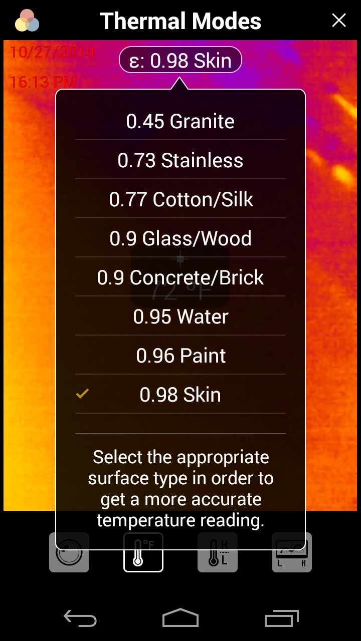
Thermal Infrared Camera..on a smart phone!
Via Wildfiretoday.com, courtesy of Bill Gabbert
A thermal infrared camera attachment for smart phone
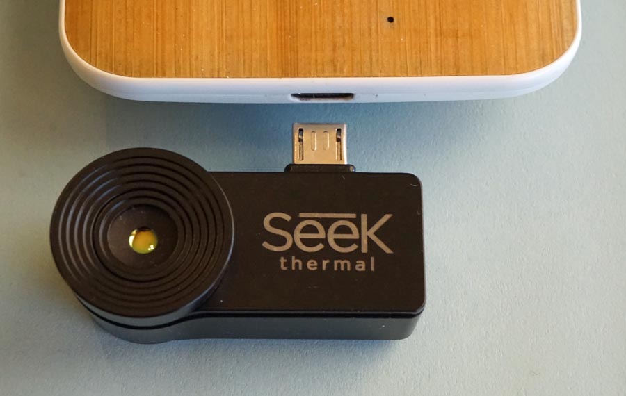 |
| Seek Thermal Camera and a Motorola X smart phone. Photo by Bill Gabbert |
A thermal infrared (IR) camera that attaches to a smart phone is now available that
could be useful forfirefighters. The device, smaller than your thumb, connects to the
USB or lightning plug on certain newer models of cell phones.
Everything (animals, humans, objects, water, etc.) emits infrared waves based on its
temperature. An IR thermal camera measures these waves, which are invisible to
human (or animal) eyes, and converts them into images.
We bought the new $200 Seek Thermal infrared camera to evaluate its effectiveness in helping wildland firefighters find lingering smoldering areas during the mopup stage of fire suppression. Under trees, organic material or duff can continue burning below the surface for days, weeks, or months and does not always produce smoke that can tip off a firefighter that the area needs attention. A still burning area that is missed can sometimes flare up and cause problems, possibly throwing burning embers across the fire line resulting in a slopover or spot fire with the potential to do serious damage.
Thermal cameras have traditionally been very expensive, which limited them to military and governmental applications. In the last ten years new, lower cost ($3,000-‐$5000+) industrial thermal cameras have emerged. They have been primarily used by police, firefighters, and contractors. Structural firefighters have used them to detect fires that are behind walls or ceilings. IR cameras can’t see through objects, but they can detect a wall, for example, that has been warmed by hidden combustion. A fire that is smoldering in deep duff in a wildfire will heat the surface of the ground, making it visible to an IR device.
Some of the wildland firefighters that have been around for a while might remember the thermal IR detector that looked like a flashlight. It had no viewing screen, but simply emitted a tone when heat was detected. I believe the pitch changed as the temperature increased. I don’t know if those are still being used. Does anyone remember what the cost of those was?
The Seek Thermal infrared camera can view long wave infrared (7.2 to 13 microns), has a resolution of 206 x 156 pixels, a 36-degree field of view, can detect temperatures between -40F (-40C) and +626F (+330C), and weighs 0.5 ounce.
At $200 the Seek Thermal infrared camera is far less expensive than other thermal infrared cameras. For example, FLIR makes many models of IR cameras. Their E4 has a resolution of 80 x 60 and sells for $995 at Amazon. The FLIR E5 with 120 x 90 resolution will set you back almost $1,500. The company recently developed the FLIR ONE, which like the Seek Thermal works with a smart phone, but is a much larger case-type design which fits entirely around the phone. It sells for $349, has a resolution of 80 x 60, and can only detect temperatures of 0 to 100C. The FLIR ONE will work with an iPhone with a lightning connector; there is no Android model.
The Seek Thermal is available in two versions: Android and IPhone. The Apple model is compatible with the iPhone 5, 5c, 5s, 6, and 6+ running iOS7 or iOS 8. The Android version will work with devices having microUSB connectors running Android version 4.3.1 (Jelly Bean) or later that support USB Host Mode (also called USB On The Go or OTG). The company says it has been tested extensively with the Galaxy S4 and S5 and the Moto G and X phones.
To use it, download the Seek Thermal app from the Apple app store or the Android Google Play store. I tested it on a Motorola X running Android 4.4.4. Helpfully, there were several prescribed fires being managed in Wind Cave National Park where I was able to find realistic conditions that wildland firefighters might run across.
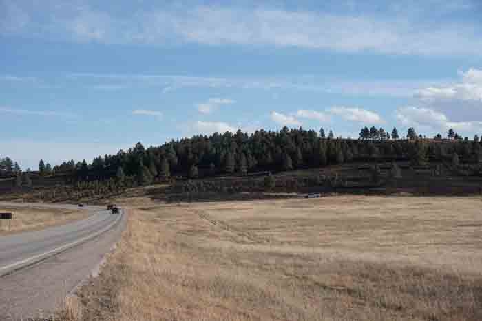 |
| This photo of Unit #3 of the Cold Brook prescribed fire was taken four days after the IR image below, from approximately the same location. Unlike the other pairs of images this photo was taken with a different camera at a different time than the pairs of Seek Thermal IR/smart phone combination photos farther down. |
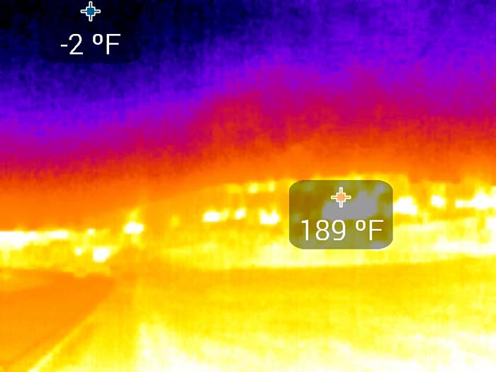 |
| An IR image of approximately the same area as the
previous photo.
This was taken October 23, 2014 with the Seek Thermal IR camera
shortly after some of the area in the image had been ignited on the Cold Brook
prescribed fire in Wind Cave National Park.
The IR image above was taken about 800 feet from the prescribed fire.The IR camera was set to display the maximum and minimum temperatures detected. Interestingly, the minimum is in the area of the sky, showing -2 F. The maximum is displayed as 189 F. |
The IR camera can be set to show the following items on the image:
- Temperature in the middle of the image; (temperatures in Fahrenheit, Kelvin, or Celsius);
- Maximum and minimum temperatures anywhere in the image;
- Only areas that have a temperature within the min/max range that you set;
- No temperatures displayed;
- Lat/long;
- Date and time;
- Options for several different “color pallets” to represent temperatures;
- A watermark for Seek Thermal, which by default is turned on, unfortunately. But, it’s easy to turn off after cruising through the menus.
You can take photos, of course, with the device. If you have the option selected for both regular and IR images, it will take and save two photos. If you have the temperatures displayed, they will also appear on the regular non-IR images.
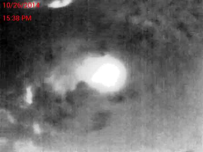
Videos are also possible, as you can see below, in this two-second thermal infrared video of firefighters near a small area of burning grass on the Cold Brook prescribed fire in Wind Cave National Park, October 23, 2014. The firefighters were from the Alpine Hotshots, preparing to ignite the prescribed fire.
More examples of images are below, showing pairs of normal photos followed by the IR version of the same area.
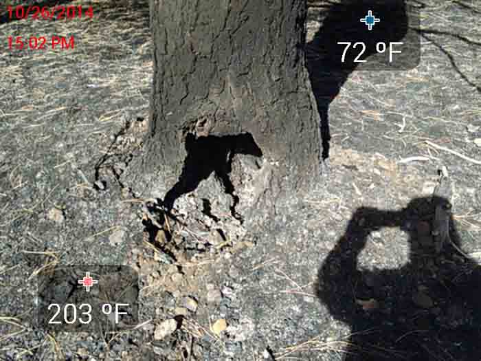 |
Note the tree’s shadow, which had been shielded from
the sun, and compare it
to the same area in the IR version below. The photographer’s shadow on the lower-right had only been present for seconds, and had not yet affected the temperature of the ground. |
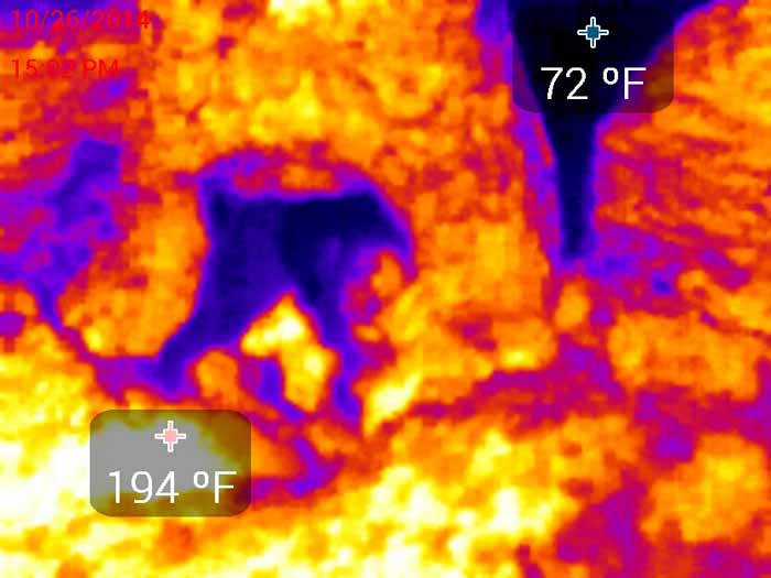 |
| IR version of the previous image. There was no visible smoke in this area. The image was taken at 3:02 p.m. MDT on a cloudless day. The air temperature, I believe, was in the 60s, but the sun heated many objects to around 100 F. The only area in this image that was still burning was the spot near the displayed temperature of +194 F. |

The two images above were taken about 15 feet from three firefighters. They were not aware of this hot spot and even when I pointed toward it from 15 feet away they were not able to see it, since there was no smoke. After we walked over to the area and stood over it, they saw that it was hot, and mopped it up with scraping tools.

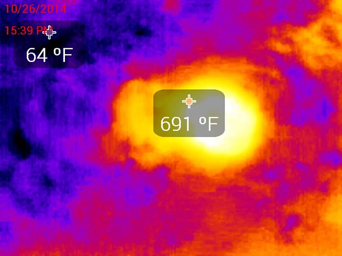
IR image with the camera set to only highlight areas
with a temperature higher than 140 F.
 |
| This single image shows how the camera can get confused when the temperature exceeds the range of the sensor, which is -40 F to +626 F. |
We hope the developers will create a “vegetation” or “wildland fire” mode for the next revision of the app.
The company does not say anything about using the device on wildfires, but they list numerous other applications, including:
Safety and Security
- Scan the dark parking lot walking out to your car to see if there are any people (or animals) around.
- See what is making that noise in your back yard at night.
- See where the heat is leaking from your house and identify leaky windows, walls missing insulation, and other sources of energy loss.
- Trace water damage up a wall or across a ceiling to its source.
- Identify the location of clogs in pipes (just run hot water down the pipe and trace where it goes and stops).
- Ensure that there aren’t any other animals in the yard before letting your dog out at night.
- Find your dog or cat at night.
- See where on the counter or furniture your animal has been sleeping while you were out.
- Measure the heat distribution across your BBQ or griddle.
- Instantly measure the surface temperature of food.
- Measure level of propane in BBQ tank
- See structures and vessels on the water at night.
- Find objects/persons that fell overboard.
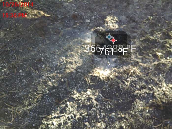
The camera displayed ridiculously wrong temperatures when very hot or flaming areas were imaged. But usually those areas are very obvious, and can be easily seen without any hand-held gadget. I was able to detect with the IR camera still burning areas that could not be found by a human, without them bending over, taking off their glove and holding the back of their hand just above the surface. Some of the areas found with the device could not even be detected with the back of the hand, unless the area was first stirred up with a scraping tool, to expose some of the hotter burning areas.
More real world experimentation by firefighters is needed, but this $200 gadget might make mopping up more efficient, and could result in fewer missed areas that need attention. It would be most useful near a fire line where it can be crucial to obtain 100 percent suppression.
Another use that could be explored is its effectiveness from a helicopter to detect a small lightning fire or abandoned campfire that would otherwise not be seen.
The Android version of the Seek Thermal IR camera can be purchased at Amazon. As this is written October 27, 2014, it is out of stock but can still be ordered.
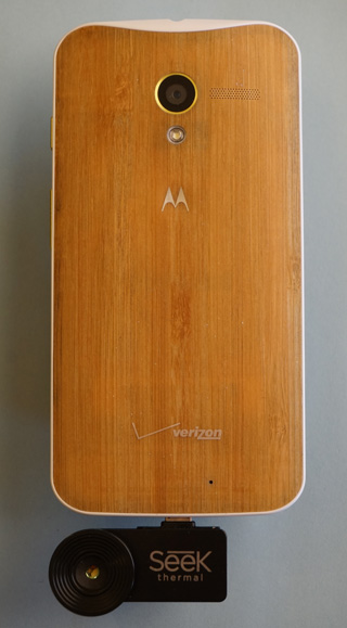 |
| Seek Thermal Infrared camera and a Motorola X smart phone. All photos in this article were taken by Bill Gabbert. |
Thursday, October 23, 2014
Weekend Rain & Possible Thunderstorms

Overview
Rain: A Pacific weather system is gathering
strength offshore. This system may spread some light rain into the North Bay
on Thursday Night, but most of the precipitation is forecast to fall from
late Friday night through Saturday as the system moves inland. Rainfall
amounts will be greatest across the North Bay and taper off quite a bit
farther to the south. Showers will linger into Saturday night with dry
weather expected to return by Sunday.
Thunderstorm Chances: A relatively unstable airmass will spread over the northern part of the region by Saturday afternoon. This will result in a slight chance of thunderstorms across the North Bay. |
CONFIDENCE
· Moderate
to High: Rain and rainfall amounts.
· Moderate
to Low: Thunderstorm chances.
UPDATED INFORMATION
· This is
the initial briefing on this weather event
TIMING
· Light
rain possible across portions of the North Bay on Thursday Night.
· Rain
chances redevelop across the North Bay late Friday Night
· Rain
likely in the North Bay on Saturday with a chance of rain elsewhere.
· A slight
chance of thunderstorms in the North Bay Saturday Afternoon
LOCATIONS
· Best
chance of precipitation is across the North Bay, as well as highest expected
rainfall totals.
· Rainfall
totals expected to fall off considerably south of the Golden Gate.
RAINFALL
AMOUNTS
· One-quarter
inch to three-quarters inch in the North Bay
· Less than
one-quarter inch elsewhere except locally higher amounts in the Santa
Cruz Mountains.
IMPACTS
· Rainfall on Saturday will result in locally difficult
driving conditions with reduced visibilities and wet roadways
· Thunderstorms may produce brief heavy downpours or
small hail.

NWS will continue to
provide email updates if the forecast changes.
Subscribe to:
Posts (Atom)