Tsunami Landslide Storm

Tsunami Landslide Storm

Tuesday, June 30, 2015

A Statewide Flex Alert is in Effect for June 30th-July 1st. Save Energy Now.


The California Independent System Operator (ISO), who monitors the electricity grid throughout California, has issued a statewide Flex Alert for June 30th-July 1st, 2:00-9:00pm on both days.
Due to the continued heat wave and subsequent rise in A/C use in addition to system constraints, electricity conservation is critical to prevent blackouts. It's important that you:
  • Turn off all unnecessary lights.
  • Postpone using major appliances until after 9:00 pm.
  • If you must use an air conditioner, adjust it up to 78° degrees or higher.
We ask that you please forward this message to your friends and colleagues.
Through conservation efforts Californians can save about 1,000 megawatts statewide which is enough electricity to power 1 million households and equal to the output of two large power plants.
Find more information at www.flexalert.org/press-releases

Beat the heat! Triple-digit temperatures the next two days


Overview

A building ridge of high pressure and a compressed marine layer will lead to very warm temperatures today and Wednesday especially for locations well inland.


TIMING

·  Today and Wednesday 

LOCATIONS

·  Mainly the inland areas with cooler temperatures expected along the coast.

TEMPERATURES

·  Highs ranging from 60s and 70s on the coast to 90s into the 100s for locations well inland.  

IMPACTS

*Hazards:

·  No watches, warnings or advisories are in place at this time. However, a special weather statement has been issued highlighting areas of concern. 
·  SFOSPSMTR


*Impact 1:

·  The expected hot weather conditions could result in heat related incidents.
*Impact 2:

·  The expected hot weather conditions could also influence fire behavior.


Plan accordingly for hot weather & keep your loved ones safe:

  • Do NOT leave kids or pets in a car, EVEN if it is parked in the shade or has the windows cracked. It only takes a few minutes for temperatures to get up to dangerous levels.
  • Reduce outdoor activities (if possible) between 11 AM - 4 PM.
  • Wear loose fitting, light clothes.
  • Eat light foods & avoid heavy meals.
  • DRINK WATER. 
  • Avoid too much sun. Sunburn reduces your body's ability to release heat.


Tuesday, June 16, 2015

Another Very Warm Weekend on the Way!


Overview

A building ridge of high pressure will lead to very warm temperatures over the weekend for inland locations.


FORECAST CONFIDENCE
·  Moderate to High
TIMING

·  Temperatures will warm through the week with Saturday and Sunday expected to be the warmest.

LOCATIONS

·  Inland locations throughout the San Francisco and Monterey Bay Region for the weekend. 

SPECIFICS

·  Widespread upper 80s to upper 90s for inland locations can be expected with a few isolated spots getting into the lower 100s. Please see the image below for specific highs on Saturday. Highs are forecast to be similar on Sunday.

IMPACTS

*Current Watches/Warnings/Advisories:

·  No watches/warnings/advisories in effect at this time
·  For all current watch/warning/advisories, http://1.usa.gov/1boSTTW

*Impact 1 (Heat) :

· Fatigue and heat related injuries such as heat stroke may occur. In addition, due to a generally cool late spring, people may be caught off-guard. People may forget to not leave pets and small animals in cars.

*Impact 1 (Fire Danger) :

· The warmer weather will combine with lower humidity values to create elevated fire weather concerns. Please note, at this time a widespread wind event is not expected to occur at the same time.


Monitor NWS Monterey Facebook and Twitter for further updates.


Monday, June 15, 2015

Two Faults Could Make One Big Earthquake

By Andrew Alden, KQED Science Contributor

Ask Bay Area seismologists their most worrisome earthquake scenario, and many will say it’s not a repeat of the great San Francisco quake of 1906. They don’t think that’s likely. Instead, it’s a possibility considered unthinkable not long ago. That would be a rupture that tears the full length of the Hayward fault, between Pinole and Fremont, then jumps past the end to the next fault.

The next fault to the north is the Rodgers Creek fault, running from San Pablo Bay into Sonoma County. Scientists have made scenarios for big quakes on the combined Hayward-Rodgers Creek. The damage from shaking, fires and landslides would exceed $200 billion.

The next fault to the south is the Calaveras fault, running from east of San Jose past Hollister. But that combination hasn’t been modeled. Until a few years ago nobody thought this deadly combo was likely.

Where the two faults merge, geologists have mapped a complex snarl of ground fractures. The faults don’t appear to line up together well, which means they would prevent any rupture from pushing through. But our maps have been too imprecise to be certain.

A new study has traced the connection between the Hayward and Calaveras faults at the surface (dashed line) and deep underground (dotted line). (Alden/Google Earth)
Now UC Berkeley seismologist Estelle Chaussard has assembled the clearest picture yet of the Hayward-Calaveras merge. Her model, just published in the journal Geophysical Research Letters, simplifies the intersection while showing that deep underground, the two faults line up dangerously straight together. But the same model helps us to simulate and plan for the hazard of a combined fault rupture.

Deep underground where earthquakes actually take place, the two faults join in a smooth line. But when geologists map the fault traces in this area – if they can even see them in the underbrush and landslide scars – the maps look as untidy as the edges of a torn-up newspaper. Moreover, they can’t tell which of the various fault traces is currently active.

Both the Hayward and Calaveras faults are known for exhibiting creep – slow, quiet motion measured in millimeters per year – but no creep measurements have been done in this rugged and remote area. (See another scientist’s earlier effort to deal with this uncertainty.)

Chaussard built the new model using two advanced techniques that sidestep the limits of what geologists on the ground can see. With these she could use the faults’ day-to-day activity, instead of their cryptic cracks on the ground, to draw their portrait.

First, she found a way to measure and map creep using InSAR (interferometric synthetic aperture radar), a satellite-based technique that’s been surveying the ground with centimeter accuracy since the early 1990s.

Selecting high-quality images from 1992 to 2011, she detected the exact zones where the ground has been creeping on both the Hayward and Calaveras faults. These curving traces mark, for the first time, the direct surface connection between the two faults. She also compared slip estimates across the merge area to show that the motions on the two faults are in balance.

Second, Chaussard selected a set of repeating small earthquakes to map the exact underground contours of the fault. She employed double-difference earthquake location, first used in 2000 on the Hayward fault, to sharpen the picture painted by these pinpricks of seismic activity.

She found that shallow quakes (less than 3 kilometers deep) lined up with the curving surface connection, the last bit of the Hayward fault. Deeper ones lined up instead with a straight plane that joins the Hayward and Calaveras faults in a single mega-fault.

 This figure from Chaussard’s paper shows on the left-hand map where repeating earthquakes (circles) and surface creep (lines) trace the southernmost Hayward fault both at the surface and at depth. On the right, her new model of the fault juncture (small square) fills in the key part of the full-size model used to simulate large earthquakes. (Chaussard/GRL)

The deep part of this combined fault is storing energy for very large earthquakes. With her new, clean images of both surface and deep activity, Chaussard built a geometric model of this crucial piece of California.

What does that mean? The U.S. Geological Survey says that an end-to-end rupture of the Hayward fault would cause an earthquake of magnitude 7.5. Adding the Calaveras to that would raise the magnitude to roughly the same size as the 1906 earthquake on the San Andreas fault. Damages from such a quake might reach $300 billion.

Until now, scientists have not been able to run realistic earthquake simulations for a Hayward-Calaveras megafault. Chaussard’s new model of their juncture will help in modeling this threatening possibility. “We hope our paper will trigger the necessary interest so that other groups start working on it,” Chaussard says.


Monday, June 8, 2015

Heat Advisory In Effect


Overview

The warmest weather of the year for inland locations is on the way for Monday. Widespread mid 80s to mid 90s are expected with a few spots into the lower 100s.

Graphic showing heat advisory for most of Monterey County (excluding coastal areas); stay hydrated and avoid strenuous outdoor activity if possible


FORECAST CONFIDENCE

·  High
TIMING

·  Monday afternoon and evening.
LOCATIONS

·  Most inland locations plus the South Bay.  Please note, this does not include the city of San Francisco.  Please see the image below for the locations impacted.

IMPACTS

*Current Watches/Warnings/Advisories:

·  A heat advisory is now in effect. For all current watch/warning/advisories, http://1.usa.gov/1boSTTW

*Impact  (Heat) :

·  The recent cooler than normal weather will be replaced by very warm to hot readings on Monday for most inland locations. In light of the recent string of cooler than normal days, many people may be caught off guard by the warm-up.


NWS will continue to provide email updates if the forecast changes.


Monitor NWS Monterey Facebook and Twitter for further updates.


Monday, June 1, 2015

Controlled Burns 6/2, 6/4, 6/6: Wildland Fire Training at Fort Hunter Liggett


2015 Wildland Firefighting Training Exercises - Fort Hunter Liggett (FHL)
Burn Dates:
June 2, 4, and 6, 2015
Name of Prescribed Burn Project:
Training Burns
Conducted by:
Monterey County Fire Training Officers Association in partnership with the Santa Cruz County Training Officers
Purpose:
Firefighter Training
Smoke Management Permit #
no permit required for training burns
North Central Coast Air Sub-Basin:
INLAND
Location:
FHL Training Area 12B in So. Monterey Co. near Nacimiento-Fergusson Rd
Acres
100 to 150 acres/day in 1 to 3 acre blocks
Type of Fuels:
grass

Thursday, May 21, 2015

"Revolutionary" fire prediction system gets support in CO


(TNS) — Colorado will spend $1.2 million over the next two years on a "revolutionary" fire prediction system that uses atmospheric weather data to predict the behavior of wildfires up to 18 hours in advance.

Gov. John Hickenlooper signed House Bill 1129 on Wednesday afternoon at a fire station in Arvada, implementing one of several bills lawmakers drafted in response to wildfires in El Paso County and elsewhere.

"This bill will predict the intensity and the direction of fires 12 to 18 hours ahead of time. That is really important so we know where to direct our planes, the aircraft we had a bill for last year, and our firefighters," said Rep. Tracy Kraft-Tharp, D-Arvada, who introduced the bill. "This is really revolutionary."

Under the new law, the Division of Fire Prevention and Control will contract with a nonprofit Colorado-based research organization with expertise in atmospheric science to predict wildfire behavior. The National Center for Atmospheric Research, a federally funded program headquartered in Boulder, is the only state agency that meets that criteria. NCAR has used modeling to accurately recreate the behavior of historic fires, including the Yarnell Hill fire that killed 19 Arizona firefighters in 2013.

She said the new technology could be in place by next spring and will work with the state's new aerial fire fleet, a multimillion-dollar investment into wildfire detecting and fighting aircraft lawmakers made in 2013.

"As we get more and more sophisticated with how we can predict storms and wind currents, that should allow us to really get a handle on which fires we should be worried about and which ones we don't have to quite get so agitated about," Hickenlooper said. "By spending this money up front, we are going to save money down the road."

©2015 The Gazette (Colorado Springs, Colo.).

Wednesday, May 13, 2015

Weather Update: Light rain expected beginning this afternoon (May 13) and continuing through tomorrow (May 14)


Overview
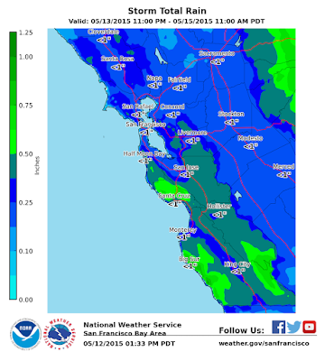
A storm system is expected to arrive to the Central California coast Wednesday evening. The storm system will be similar to last-weeks storm system that brought generally light rain to the area with a few isolated thunderstorms. This storm system will begin to impact the area with a possibility of light showers as early as Wednesday afternoon with steadier rainfall arriving late Wednesday night early Thursday morning. Moderate showers and isolated thunderstorms will be possible late Thursday morning lasting into the early afternoon hours. The main impact with this storm system will be wet road ways with minor ponding possible. A few lightning strikes will also be possible with the thunderstorm threat. Dry, cool weather is anticipated late Friday morning through the weekend         

Graphic showing rainfall amounts for Monterey County; Amounts vary, but all are under an inch total


TIMING

·  Showers arriving as early as Wednesday afternoon.
·  Steadier rainfall expected Wednesday night persisting into Thursday evening.
·  Moderate showers and isolated thunderstorms possible Thursday afternoon.
·   Dry, cool weather expected to return late Friday morning.  

IMPACTS

*Impact 1 (Rain) :

·  Rainfall will be steady with total precipitation ranging between 0.25 and 0.80 inches, heaviest in the hills. The rain will result in wet roadways and minor ponding.  

*Impact 2 (Thunderstorms):


·  Isolated thunderstorms will generate a few lightning strikes.
  

Tuesday, May 12, 2015

Caregivers, Are You Ready for a Disaster?

Author: 

Daddy and I were walking across the living room one night recently when the house suddenly went dark. The power was out, but fortunately, I was prepared.emergency checklist
Plugged into the outlet in front of us was a power-failure light that comes on automatically. It also serves as an automatic nightlight and a portable flashlight. I have the lights strategically plugged in throughout the house, and they lit our way to safety.
I also realized that no electricity meant no air-conditioning, which quickly can become unbearable in Phoenix. Once I got Dad settled, I made plans to move him to an air-conditioned location in case power wasn't rapidly restored.
When you’re a caregiver, it’s crucial to be ready for these kinds of emergencies. Especially with severe summer weather coming — hurricanes, tornadoes, fires — now is the time to think about preparing your loved ones for natural disasters.
Amy Goyer gives tips for caregivers to prepare for disasters and other emergencies.
When we lost electricity I was prepared with power-failure lights and lanterns.


In addition, here are some things caregivers should focus on when preparing for emergencies:
  • Financial and legal preparedness: I’m making sure key documents for Dad’s financial records, health care power of attorney and other advance directives are easy to access in case of an emergency where we need to evacuate quickly. Dad’s attorneys and accountant have copies of everything, and I also have electronic copies available via a secure online storage app.
  • Alerts and warnings: I receive wireless emergency alerts automatically on my smartphone, but I've also checked out other options for local alerts. In Monterey County, visit AlertMontereyCounty.org to sign up.
  • Emergency communication plans: With contact lists always handy in our smartphones, few of us have memorized key phone numbers. But you can’t always depend on cellphone service under severe conditions, so I also have a written list of key family members’ contact information. Would your loved ones know how to contact you in an emergency?
  • Emergency supplies: My power-failure lights in the house are just one way to be prepared. I also have emergency health supplies in our cars and in our home. I always keep some bottled water in the house, and Dad’s medications and mine are in containers that would be easy to take with us. Keeping a basic disaster supply kit in a handy location is a good idea; if you’ve already done that, you need to check the supplies once a year to be sure everything is still in good condition.
  • Property and insurance: I plan to take photos of both Dad’s and my property and double-check our insurance coverage. I have digital copies of many family photos, but I realize I need to scan some of the older photos to ensure they wouldn’t be lost in a disaster.
There’s great information on preparing for these and other hazards, as well as advice on how to recover from a disaster, at www.ready.gov. And you’ll find more of my tips on caregiving crisis management in my book, AARP’s Juggling Work and Caregiving.


Amy Goyer is AARP’s family, caregiving and multigenerational issues expert; she spends most of her time in Phoenix, where she is caring for her dad, who lives with her. She is the author of AARP’s Juggling Work and Caregiving. Follow Amy on Twitter @amygoyer and on Facebook.

Tuesday, May 5, 2015

2015 “Wildfire Awareness Week” Declared in California for May 3-9


Sacramento – As drought conditions continue to significantly elevate Californias fire danger, Governor Edmund G. Brown, Jr. has declared May 3-9, 2015 asWildfire Awareness Week”. During Wildfire Awareness Week, CAL FIRE is reminding all Californians of the role they play in preparing for and preventing wildfires.

“With a record dry and warm winter Californian’s fire activity has been nearly double what it normally is for this time of year, said Chief Ken Pimlott, CAL FIRE director. “Our firefighters continue to meet the challenges posed by Californias historic drought, but we all must do our part to ensure our homes are prepared for wildfire and that residents and visitors to our state take extreme caution to avoid sparking a wildfire.

On May 1, the Department of Water Resources (DWR) announced that California’s snowpack water content was only 3 percent of normal. The lack of snow and overall rainfall has led to conditions being much drier than normal, lending themselves to the quick spread of wildfire. Between January 1 and May 2, CAL FIRE has responded to over 1,100 wildfires that have charred over 4,200 acres. In an average year for the same time period, CAL FIRE would typically respond to fewer than 650 wildfires burning approximately 1,500 acres.

During Wildfire Awareness Week, CAL FIRE is reminding Californians that when it comes to wildfires, remember Ready, Set, Go!”. Being Ready for a wildfire starts by maintaining 100 feet of Defensible Space and hardening homes with fire resistant building materials. During this drought CAL FIRE is highly recommending residents landscape their yards with drought tolerant and fire resistant plants. Being Set includes have an evacuation plan and an emergency supply kit. Lastly, when a wildfires strikes, residents are urged to Go! and evacuate early.

CAL FIRE is also urging all Californians during Wildfire Awareness Week to learn the steps to prevent sparking a wildfire. Over 90 percent of the wildfires in California are sparked by the activity of people, so CAL FIRE has joined local and federal fire agencies in the One Less Spark, One Less Wildfire” campaign in hopes of getting the public to practice fire safety outdoors and prevent sparking a wildfire.


Residents looking for additional information on how to prepare themselves, their families and their homes for wildfire can visit www.ReadyForWildfire.org. The site offers tips for residents to make their homes more resistant to wildfires and to ensure that their families are ready to evacuate early and safely when a wildfire strikes.

For more than two years, California has been dealing with the effects of drought. To learn about all the actions the state has taken to manage our water system and cope with the impacts of the drought, visit drought.ca.gov.

Every Californian should take steps to conserve water. Find out how at SaveOurWater.com